PAGASA signals explained: what to do at each level
PAGASA wind signals 1 to 5 explained simply: what each level means for lead time, wind, and what to actually do before the next typhoon hits.
The situation
The first typhoon season after you move to Metro Manila or Cebu is confusing in a particular way. Everyone around you seems to know what “Signal No. 2” means, the group chat is full of screenshots, your landlord says “okay lang yan”, and you are left guessing whether to buy water or just go to work.
So here is the thing nobody says out loud early enough: the wind signal is about wind, and about how much time you have left. That is all it is. It is not a rating of how bad the storm will be for you. It is not a flood warning. It does not tell you whether your street will be knee-deep by Thursday morning.
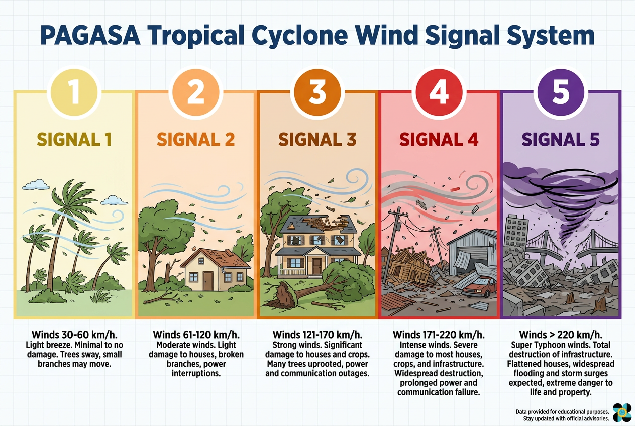
PAGASA raises a Tropical Cyclone Wind Signal over an area when winds of a certain strength are expected within a certain number of hours. Signal No. 1 comes with roughly a day and a half of warning. By Signal No. 4 or 5 you are looking at about twelve hours. The number going up means two things at once: stronger wind, and less time.
That is genuinely useful. But the storms that have hurt people in this country most were not always high-signal storms. The 2009 flood that put Marikina under water came from a cyclone that was never especially windy over Metro Manila. It just rained an absurd amount in a short time. Every wet season since, I have watched the habagat — the southwest monsoon, pulled in and fed by a storm sitting hundreds of kilometres away — flood low-lying barangays while no signal was raised over the city at all.
So you need to read two streams at once: the wind signal for wind and lead time, and the rainfall and flood advisories for water. Then a third: what your LGU actually announces.
What actually matters
Lead time, not drama. Treat the signal as a countdown clock. Signal No. 1 means you have time to think. Signal No. 4 means the thinking should already be done.
Rainfall warnings are a separate system. PAGASA issues heavy rainfall warnings in colours — yellow, orange, red. Yellow means flooding is possible in low-lying areas. Orange means flooding is threatening. Red means serious flooding is expected and you should be acting, not watching. A red rainfall warning over your city matters more to a ground-floor flat in a flood-prone barangay than the wind signal does.
Your building and your street decide half of it. A concrete mid-rise in Quezon City and a light-roofed house near the coast in Cebu experience the same Signal No. 3 completely differently. Know which one you are in. Ask neighbours who have been there ten years how high the water came in the worst year. That single conversation is worth more than any bulletin.
The LGU has the final word on practical things. Class and work suspensions, pre-emptive evacuation, forced evacuation of specific barangays — those come from your city or municipality, not from PAGASA. The national suspension rules have been adjusted more than once in recent years, so I no longer try to recite them from memory. I follow my LGU’s official page and I check it again in the morning.
Power and water go before the worst of it, and come back after. Distribution utilities will sometimes cut power pre-emptively in high-signal areas, and that is a sensible thing for them to do. Plan for the lights to go out before the wind peaks, not after.
Signal by signal: what I actually do
These are my own habits, adjusted for a flat on a mid floor in the city. Scale them to your building, your street, and how far you are from the coast.
Signal No. 1 — the thinking window
Roughly a day and a half of warning. Light damage: branches down, banana plants flattened, old roofing sheets rattling. Most of the city carries on normally, and mostly that is correct.
At this point I would:
- Read the actual bulletin once, properly, including the forecast track. Not a screenshot.
- Check water: are the containers full, do I have drinking water for a few days.
- Check the torch and the power bank. Charge both. This is the cheap, boring step people skip and then regret.
- Look at the shopping. If I am short on rice, tinned fish, cooking gas or baby formula, I buy now, while the shops are calm and prices are normal.
- Check my phone’s stored cash and whether I have small notes at home. Card terminals and GCash both depend on power and signal.
- Check the rainfall outlook separately, and ask myself honestly whether my street floods.
Signal No. 2 — get ahead of it
About a day of warning, and now winds that genuinely take down old trees, light roofing and signage. This is where I stop treating it as background noise.
At this point I would:
- Bring in everything loose from the balcony or yard: plants, drying racks, chairs, the plastic basin, the bicycle. Anything that can fly is a problem for someone downwind.
- Move the car. Out of anything low-lying, away from trees and old billboards, ideally into a multi-storey car park or onto higher ground. Moving a car is a five-minute job on a quiet Tuesday and impossible on a flooded Thursday.
- Charge everything — phones, power banks, laptop, the rechargeable fan and the emergency lights. Fully, not to 70%.
- Fill water containers, including a bathtub or drums for flushing if you have them.
- Tell the family the plan out loud. Where we go, who we call, what we take. Especially with young children.
- Watch for class suspension announcements that evening rather than in the morning scramble.
Signal No. 3 — this is the serious one
About eighteen hours out. Significant damage to light structures, trees down across roads, widespread power interruptions. In my experience this is the level where ordinary city life actually stops.
At this point I would:
- Not travel. No errands, no “quick trip”, no airport runs. Flights and ferries will be cancelled anyway.
- Decide, finally, whether we are staying. If the house is old, light-roofed, coastal, near a river or in a barangay the LGU has evacuated before — we go now, while roads are passable and it is still daylight.
- Move valuables, documents and electronics up a floor or into sealed containers. Passports and IDs into a dry bag, on my person or in the go-bag.
- Cook something substantial and eat properly. Being fed and warm before a long night is underrated.
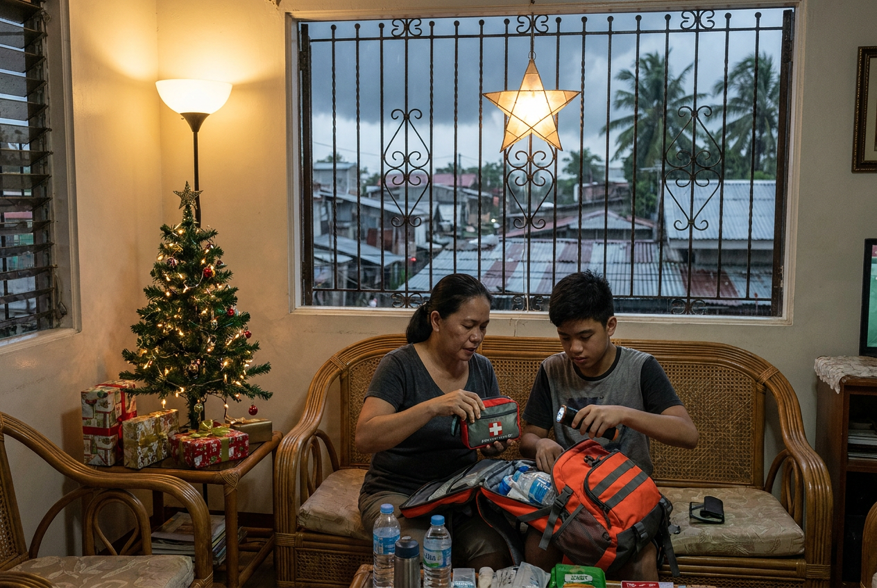
- Fill the go-bag properly and put it by the door, not in the cabinet.
- Turn on a battery radio and leave it on low. When the mobile network sags — and it does — that radio is your last honest link.
Signal No. 4 — you should already be where you are staying
Twelve hours or so. Severe damage. Roofs peeled off, concrete hollow-block walls damaged, most power out over a wide area.
At this point I would:
- Stay put, away from windows. Interior room, ground level if there is no flood risk, upper level if there is.
- Assume power is going and water pressure will follow.
- Keep the phone on power-saving and stop scrolling. Battery is a resource now.
- Have torches within arm’s reach of each person, not one shared torch in the kitchen.
- Stop deciding. If you have not left, you are staying. Moving at this point is more dangerous than the building.
Signal No. 5 — extreme, and rare
Catastrophic wind. This is the level associated with the very worst storms, and it is not raised often. If Signal No. 5 is up over your area, the only correct sequence is: you evacuated earlier, on the LGU’s word, to a substantial building. There is no clever household preparation that makes a light structure survive this. There is only having gone.
In search-and-rescue, the operations that went badly were almost never the ones where people had bad equipment. They were the ones where people moved late — where a decision that would have been easy at four in the afternoon got made at nine at night, in the dark, in the rain. That pattern is the same here. No bag replaces leaving early.
The gear that helps
Nothing exotic. The things that quietly earn their keep every season:
- A torch each, plus a lantern. One shared torch turns a household into a queue. See our power outage notes.
- A power bank you have actually tested. Honest about what it is: a pocket top-up, not a house battery. More in stay connected.
- A small battery or crank radio. Around ₱800 to ₱1,500 for something decent. When the towers are congested, this still works.
- Water storage and a way to make water safe. Containers first, filter second. See clean water.
- A dry bag for documents. Cheap, ₱300 to ₱600, and the one thing you will be glad of if water gets in. See flood ready.
- A packed go-bag you can carry one-handed while holding a child’s hand. Weight discipline matters more than features. See go bag.
- A small stove and fuel if your kitchen is electric or your gas runs out. Covered under off grid.
We buy our own gear. Nothing here was sent to us.
Common mistakes
Treating the signal as a rain forecast. It is not. Check the rainfall warnings and flood advisories separately, every time.
Waiting for the panic buying to start before shopping. By then the water shelves are empty and the queues are an hour long.
Charging devices at Signal No. 3. Too late. Power often goes before the wind peaks.
Leaving the car in a low-lying spot “just overnight”. I have watched this specific mistake cost families more than everything else in the house combined.
Trusting a screenshot. More on this below, because it is the big one.
Assuming a strong building means safe. A solid building in a flood-prone street is still a flood-prone street. Different risk, same water.
Ignoring a pre-emptive evacuation order because it looks fine outside. Pre-emptive means before it looks bad. That is the entire point.
Where to get the real bulletin
Go to PAGASA directly: pagasa.dost.gov.ph, and the official DOST-PAGASA social media accounts. Severe weather bulletins are issued at regular intervals and more frequently as a cyclone nears or crosses land, so a bulletin can be superseded within hours. For rainfall, look for the heavy rainfall warnings and flood advisories, which are issued separately and often more urgently. For suspensions and evacuations, follow your city or municipal government’s official page, and your barangay.
And this is why the screenshots going round Facebook and Viber are so often wrong. A screenshot has no live timestamp. It might be from this morning’s bulletin or from three days ago, or from a storm two years back, or it might be a model spaghetti plot from an unofficial page that was never a forecast in the first place. It gets re-shared with an alarming caption, stripped of its context, and by the time it reaches your group chat the track has shifted and the signals have changed. I have seen people prepare for the wrong day because of it.
Check the source. Check the time it was issued. If you cannot see both, do not act on it.
The one thing to remember
The signal number is a countdown, not a verdict. Use the early numbers to buy yourself time — charge, shop, move the car, agree the plan — so that by the time the high numbers arrive, you are not making decisions in the dark. And keep one eye on the rain, always, because the water has hurt far more households in this country than the wind ever has.